NASA

Landsat 9 Sees Buccaneer Archipelago

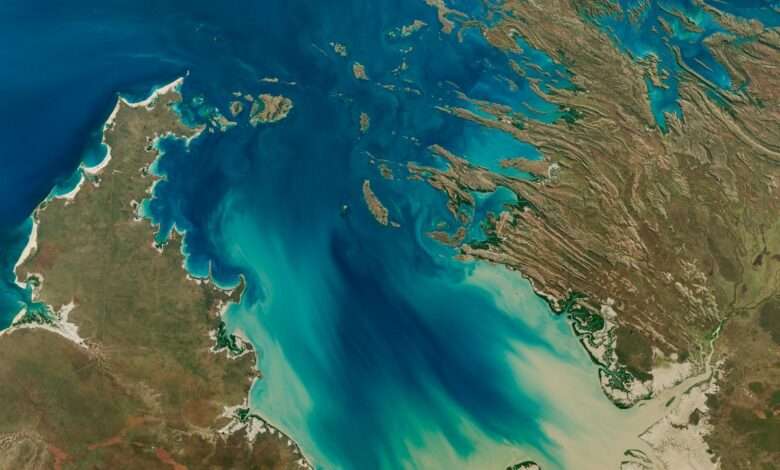
The Operational Land Imager on Landsat 9 captured this image of Buccaneer Archipelago on June 11, 2025. The scene encapsulates the striking interactions between land and water in the area where King Sound opens to the Indian Ocean.

The powerful tidal currents stir up sediment in shallow areas, producing the beautiful turquoise swirls visible in this image. This power, however, can be hazardous to seafarers and divers as water rips through the archipelago’s constricted passages. One infamous place of turbulence, known as “Hell’s Gate,” lies in the passage between Gerald Peninsula and Muddle Islands.

Learn more about this archipelago in Western Australia.

Text credit: Kathryn Hansen

Image credit: NASA/Michala Garrison; U.S. Geological Survey

About The Author

Ben

I am the owner of Cerebral-overload.com and the Verizon Wireless Reviewer for Techburgh.com. My love of gadgets came from his lack of a Nintendo Game Boy when he was a child . I vowed from that day on to get his hands on as many tech products as possible. My approach to a review is to make it informative for the technofile while still making it understandable to everyone. Ben is a new voice in the tech industry and is looking to make a mark wherever he goes. When not reviewing products, I is also a 911 Telecommunicator just outside of Pittsburgh PA. Twitter: @gizmoboaks

Related Articles

Leave a Reply

This site uses Akismet to reduce spam. Learn how your comment data is processed.

Back to top button