Earth planning date: Monday, Sept. 23, 2024
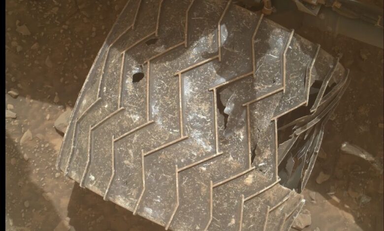
After a busy weekend of activities, Curiosity is ready for another week of planning. One of the activities over the weekend was our periodic check-in on our wheels to see how they are holding up on the rough terrain. The image shows the MAHLI view of the right-middle (RM) wheel, which is still holding up well despite taking some of the worst abuse from Mars.
We are planning contact science with APXS and MAHLI on “Burst Rock,” which is a target that has an interesting texture and has bright-toned clasts and a gray coating. It is part of the Gediz Vallis Ridge channel deposits and will help out understanding of the channel. Unfortunately, it was too rough to brush, but it is clean enough that we can still get good science data.
We are doing a lot of imaging and remote science today. We are taking Mastcam mosaics of multiple targets. “Log Meadow” is a target designed to get a look at the distribution of the white stones in the channel. “Grand Sentinel” is a target on the opposite side of our previous workspace, allowing us to document it from a different angle. “Tunnel Rock” and “Tombstone Ridge” are sedimentary rocks that may have ripple-like layers; examining the layer contours helps inform how rocks were formed. Lastly, “Gravel Ridge” is a target in “Arc Pass” where we are continuing to examine clasts and sedimentary layers. We also take a ChemCam LIBS observation of Log Meadow and a long-distance RMI image of “Chanbank,” another area of white stones. We round it off with a Navcam mosaic of the rover to monitor dust on the deck.
After wrapping up the targeted and contact science, we’re ready to drive. As the science team had time to look a bit more at the data collected in that region, they discovered this target that was worth going back for. We are driving back to the area of the white stones to do more contact science on rocks that look similar to the elemental sulfur we saw earlier this year. Planning ahead, I got to scout this drive on Friday, laying out the safest path and looking for parking spots that were both good for communications as well as for doing contact science. The target “Sheep Creek” is about 50 meters (about 164 feet) to the northeast, which makes the drive a challenge — the resolution of our imagery at that range makes it harder to pinpoint these small rocks. We do have really good imaging in that direction, and the terrain isn’t super scary, so the Rover Planners are going to try to make it in one drive. During the drive, we will be taking a MARDI “sidewalk” movie (a series of images looking below the rover for the entire length of the drive), which will help document the channel. On the second sol of the plan, we do some additional atmospheric and untargeted science. We have a Navcam suprahorizon movie (looking at the crater rim to evaluate dust in the atmosphere) and a dust devil movie. We also have a ChemCam AEGIS observation, where the rover will autonomously select a target to image. Overnight, CheMin does an “empty cell” analysis to confirm that the system is cleaned out and ready for the next sampling campaign.
Written by Ashley Stroupe, Mission Operations Engineer at NASA’s Jet Propulsion Laboratory