Sols 4389-4390: A Wealth of Ripples, Nodules and Veins
Earth planning date: Monday, Dec. 9, 2024
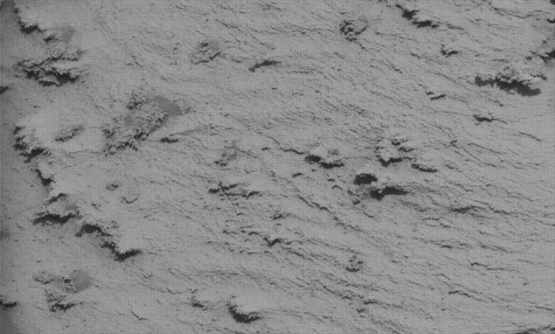
We are continuing to edge our way around the large “Texoli” butte. Much of the bedrock we have been traversing recently looks pretty similar — paler-colored laminated bedrock — but today’s workspace had some interesting features, as did the “drive direction” image, which focuses on the future drive path.
Close to the rover, we had a wealth of fractures and darker-toned patches. The fractures or veins were too far from the rover for contact science, but ChemCam LIBS was able to target one of the more prominent ones at “Garlock Fault.” Luckily for the contact science instruments (APXS and MAHLI), the darker patches were within reach of the arm. Some of the darker patches were flatter and platy in appearance, whilst others had a more amorphous, blobby shape. Both types come with their own challenges. The flatter ones collect dust on their flat surfaces, so ideally they would be brushed with the DRT (Dust Removal Tool) before we analyze them, but they are often too fragile-looking, and we worry that some of the layers might break off or flake off. The amorphous ones have irregular surfaces, which can collect sand and dust and make getting a good placement tricky.
However, today we were able to get both APXS and MAHLI on the flattest, most dust-free looking patch at “Cerro Negro.” We will be able to compare the composition of the darker patches and the Garlock Fault vein, and hopefully tease out their relationship.
Mastcam will take a small mosaic of Garlock Fault and then a larger mosaic on crosscutting veins at “Wildwood Canyon.” This was previously imaged, but from a different angle, so getting a second image will allow us to calculate the orientations on the fractures. Further afield, the “Forest Falls” mosaic looks at an area of dark, raised vein material.
Looking at the drive direction image, the sedimentologists were very excited to see what appear to be ripple features in the rocks ahead of us, which can tell us a lot about the depositional environment. The Mastcam mosaic “Hahamongna” will image the outcrop we are driving towards (about 30 meters from today’s workspace, or 98 feet), to give context for what we see when we get there. Mastcam will take a second smaller mosaic at “Malibu Creek” midway between where we are today and where we hope to be on Wednesday.
Looking even further into our future driving path, we will obtain Mastcam and ChemCam RMI images of the top of Mount Sharp and the yardang unit. We have a bit to go before we get there of course, but we will use those images to examine structural relationships and consider the evolution of both — we can test all those theories when we get there!
We round out the plan with environmental monitoring, as always …and wait eagerly for the next workspace on Wednesday, when we will get up close to those ripples, with luck!
Written by Catherine O’Connell-Cooper, Planetary Geologist at University of New Brunswick

