On March 3, 2026, Earth lined up directly between the Moon and the Sun, casting its shadow on the full Moon. The total lunar eclipse was visible throughout the Americas, East Asia, Australia, and the Pacific. Skygazers in those parts of the world may have witnessed a “Blood Moon,” when the dimmed lunar surface temporarily turned an orange-red color.
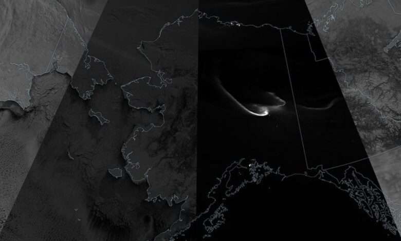
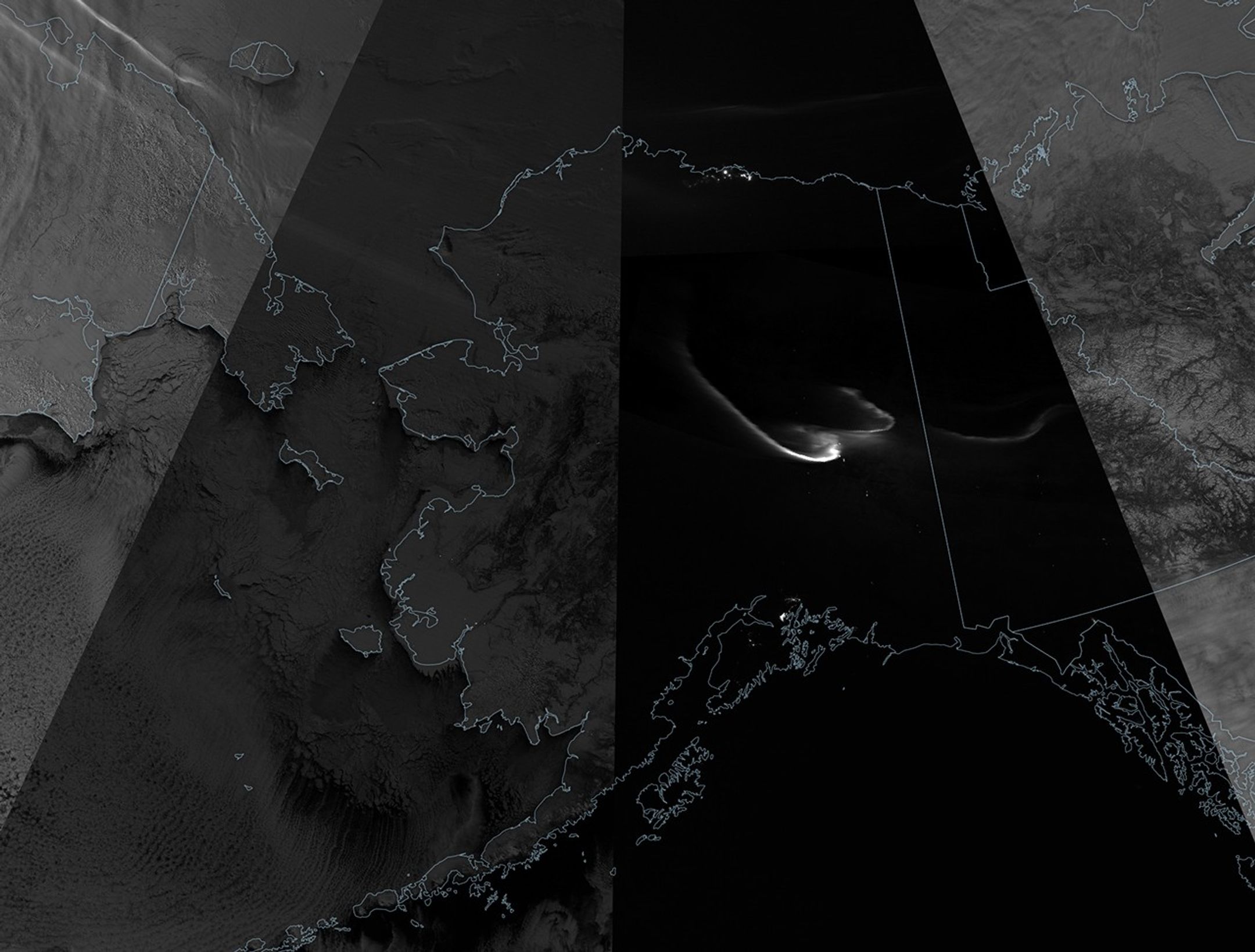
Meanwhile, satellites observed the effect of the darkened Moon on Earth’s surface. Changes in the amount of moonlight reflected back to Earth as the eclipse progressed appear in this composite image, composed of nighttime observations made by the VIIRS (Visible Infrared Imaging Radiometer Suite) on the NOAA-21 satellite. The satellite collected these images of the Arctic about every 100 minutes, with earlier swaths toward the right and later swaths to the left.
The VIIRS day-night band detects nighttime light in a range of wavelengths from green to near-infrared and uses filtering techniques to observe signals such as city lights, reflected moonlight, and auroras. The darkest swath was acquired at 11:20 Universal Time (2:20 a.m. Alaska Standard Time), about 15 minutes after the total phase had begun. With very little moonlight reaching Earth, ribbons of light from the aurora borealis shine through, along with specks of artificial light from settlements in the Yukon and eastern Alaska.
When the satellite passed over western Alaska and the Bering Strait, at 13:00 Universal Time (4:00 a.m. Alaska Standard Time), the eclipse was in the partial phase. The scene is noticeably brighter than the earlier one, and light from the partially shaded Moon illuminates snow-covered topography and offshore clouds. The brightest swaths on the far right and left sides were acquired before and after the eclipse, respectively, with light from the full Moon.
The next chance to view a total lunar eclipse will occur on December 31, 2028, when it will add a dash of astronomical flair to New Year’s Eve celebrations in Europe, Africa, Asia, Australia, and the Pacific.
NASA Earth Observatory image by Michala Garrison, using VIIRS day-night band data from NASA EOSDIS LANCE, GIBS/Worldview, and the Joint Polar Satellite System (JPSS). Story by Lindsey Doermann.
Downloads
March 3, 2026
JPEG (1.52 MB)
References & Resources
- CIMSS Satellite Blog (2026, March 3) VIIRS Day/Night Band imagery showing the effect of a total lunar eclipse. Accessed March 9, 2026.
- NASA The Moon & Eclipses. Accessed March 9, 2026.
- NASA (2026, January 29) March 2026 Total Lunar Eclipse: Your Questions Answered. Accessed March 9, 2026.
- NASA (2009, April 29) Total Lunar Eclipse of 2026 Mar 03. Accessed March 9, 2026.
- NASA Earth Observatory (2025, September 20) By the Warm Light of the Moon. Accessed March 9, 2026.
- NASA Earth Observatory (2008, March 13) Lunar Eclipse from Orbit. Accessed March 9, 2026.