


Advancing Earth Observation at NASA Since Release of Earthrise Photo
When NASA’s Apollo 8 crew rounded the far side of the Moon in 1968 and astronaut Bill Anders snapped a picture of Earth peeking above the gray horizon, the image became a symbol of hope in challenging times. The photograph, Earthrise, as it came to be called, helped inspire the first Earth Day celebration two years later.
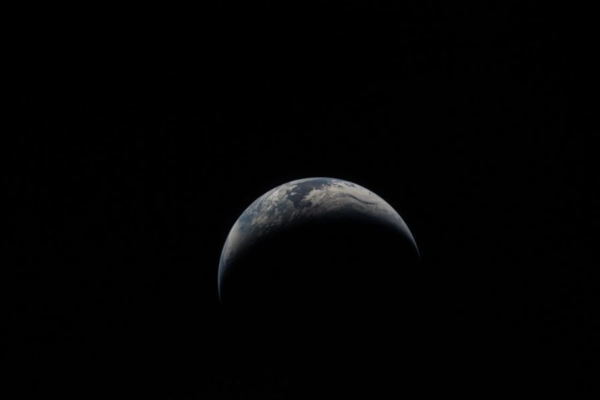
This year, the astronauts of the Artemis II mission captured their own poignant images of home. The newly released photo shows Earth on April 6, as the crew traveled farther than any humans before them.
“On Earth Day, we are reminded of the extraordinary responsibility we share to understand our planet,” said NASA Administrator Jared Isaacman. “NASA’s Earth science missions continue to deliver critical data that strengthen communities, support industries like agriculture, and help the nation anticipate and respond to wildfires, droughts, flooding, and other natural hazards. Together with our Earth science partners, NASA is committed to deepening our understanding of Earth.”
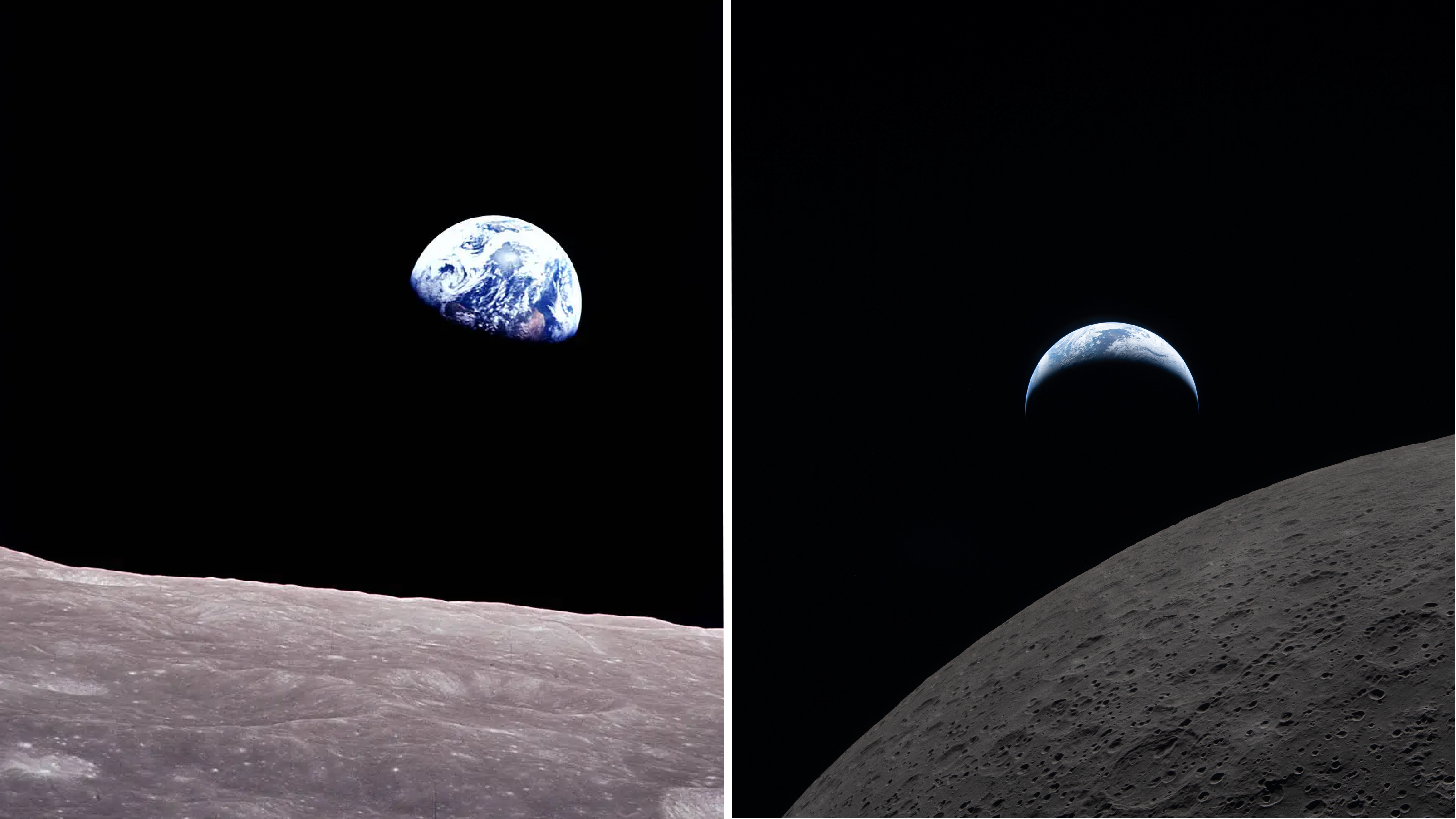
Left: Earthrise on Dec. 24, 1968, memorialized by the Apollo 8 crew in Kodak Ektachrome color film. Right: A crescent Earth hovers just above the lunar surface, minutes before Earthset. This photo was captured on April 6, by the Artemis II crewmembers through the windows of the Orion spacecraft shortly before they flew behind the Moon and journeyed farther from Earth than any other humans have traveled.
NASA
From cameras pressed against spacecraft windows to the most powerful radar ever flown, imaging technology has taken giant leaps since 1968, but the drive to understand our home in the cosmos has remained.
“Our four Artemis II astronauts — Reid, Victor, Christina and Jeremy — took humanity on a journey that showed us just how special and bright our Earth is, even from the dark side of the Moon, that is especially worth celebrating on Earth Day,” said Nicky Fox, associate administrator of the Science Mission Directorate at NASA Headquarters in Washington. “Seeing the incredible images of our blue marble planet over time from Apollo 8’s Earthrise to Artemis II’s Earthset, it is not only a symbolic moment of beauty, but like the other images captured during the lunar flyby, Earthset is brimming with incredible science in high definition that will help inform our future Artemis missions on the Moon.”
Here’s a look at how NASA’s view of Earth has advanced since that early image of the planet.
Sea level to soaring
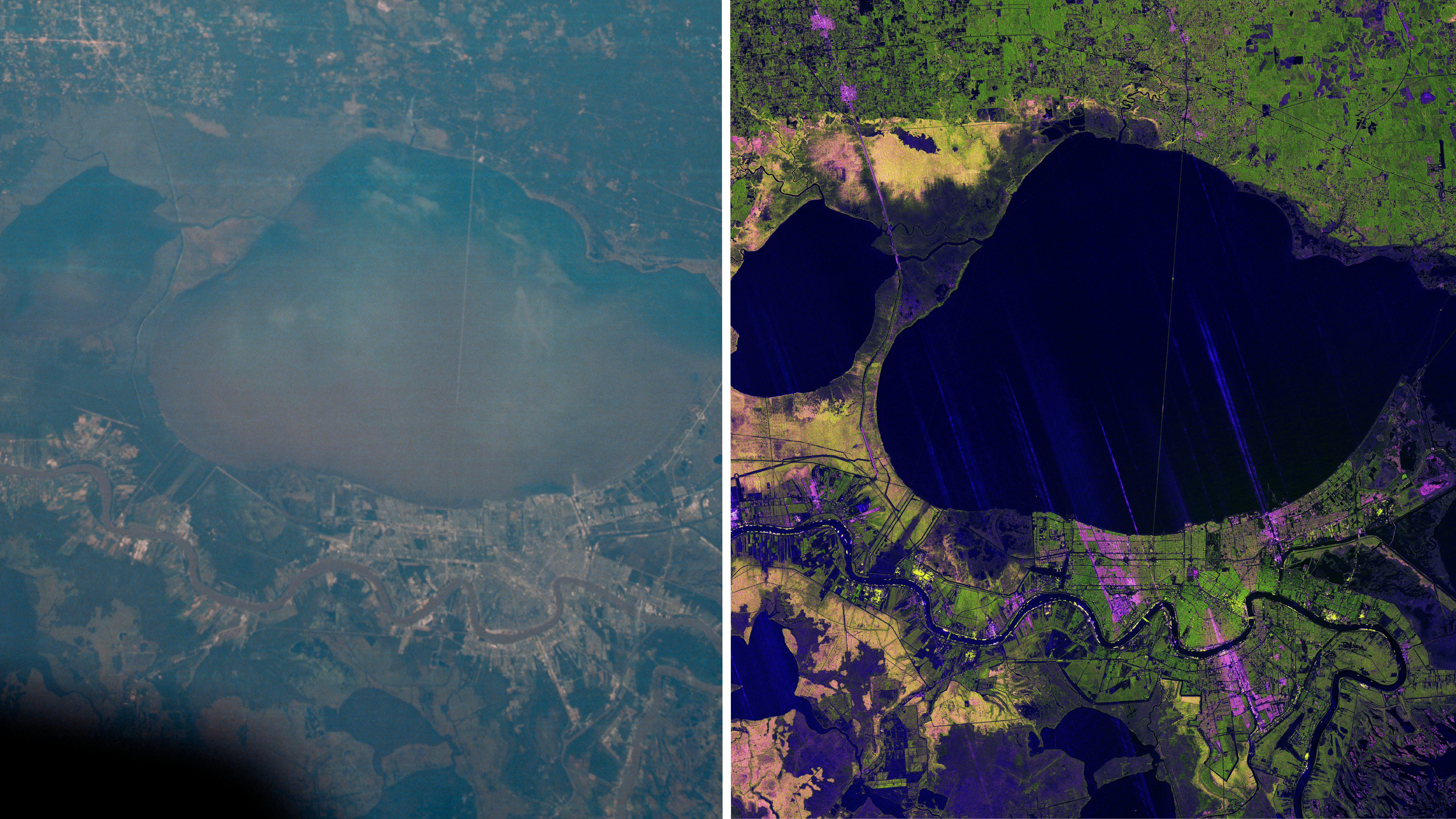
A photograph of the greater New Orleans area, including Lake Pontchartrain and its nearly 24-mile causeway, taken by the Apollo 7 crew (left) in 1968. Right: an image created using recent NASA-ISRO Synthetic Aperture Radar (NISAR) data. The various colors indicate wetlands, city streets, and other kinds of land cover, which reflect radar signals differently.
NASA/JPL-Caltech
In 1968, during their 120th revolution around the planet, the Apollo 7 astronauts snapped a photo of New Orleans, visible amid the green wetlands and tan sediment of the Mississippi River Delta, some 95 nautical miles below. Today, space-based radar is revealing how the earth beneath our feet is rising, sinking and sliding.
Launched in July 2025 by NASA and the Indian Space Research Organisation (ISRO), NISAR’s (NASA-ISRO Synthetic Aperture Radar) L-band and S-band SAR instruments can penetrate clouds and tree canopies to reveal details of Earth’s surface and observe changes. That’s actionable information for communities, including low-lying cities at risk of losing ground due to rising seas and subsiding land.
The NISAR mission continues a long legacy of Earth-observing satellites. Around the globe, from ice to deserts, NASA’s satellite record has chronicled changes to the human and natural world for decades. See how the recently launched PACE (Plankton, Aerosol, Cloud, and Ocean Ecosystem) satellite captured the Mississippi River Delta swirling with marine life.
“The Artemis photos shared with all of humanity the breathtaking beauty of our home planet, as it can only be seen from space,” said Karen St. Germain, division director, NASA Earth Science Division. “NASA’s fleet of Earth science satellites provide additional dimensions to this beauty, by teaching us how our planet supports the vibrant and dynamic forms of life we see on Earth. This data and discovery help us deliver actionable science so we can continue to thrive on our ever-changing planet.”
Got a Questions?
Find us on Socials or Contact us and we’ll get back to you as soon as possible.