On July 23, 1972 the first civilian satellite designed to image Earth’s land surfaces was launched from Vandenberg Air Force Base in California. On board the satellite, originally named the Earth Resources Technology Satellite (ERTS), but later known as Landsat 1, were two sensors. The primary sensor, called the Return Beam Vidicon (RBV), used three shuttered cameras to take photographs; the secondary sensor, the Multispectral Scanner System (MSS) was an experimental instrument.
Both sensors were packed onto a “butterfly-shaped” spacecraft repurposed from the successful Nimbus weather missions. There were strict size and weight limitations for the sensors, especially the experimental MSS that weighed less than the primary RBV sensor and the data recorder. (At over 150 pounds, the data recording system onboard was the biggest recording device ever orbited.)
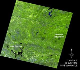
A color composite (MSS bands 6,7,5) showing the first cloud-free land image acquired by the Landsat 1 multispectral scanner system (MSS), on July 25, 1972, including the Ouachita Mountains in southeastern Oklahoma. The dark stripe above the image center results from several dropped MSS scanlines.
NASA/USGS
The MSS technology was a novel way of looking at Earth. It used a scanning mirror to build up an image pixel-by-pixel with six scan lines sweeping across the satellite’s ground path 13.62 times per second as the satellite hurtled around Earth at over 14,400 mph. As the first civilian imaging scanner to orbit Earth, many of the scientists and engineers outside the small cadre of scanner enthusiasts wondered if the satellite’s MSS instrument would be able to successfully produce an image traveling at such a high velocity. This made for a harrowing day when the first imagery was transmitted back to Earth two days after launch.
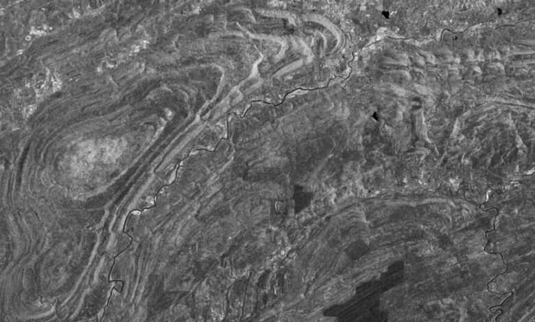
A group of Landsat scientists and engineers gathered in the Landsat data processing facility at NASA’s Goddard Space Flight Center as the first MSS digital transmission was translated onto 70-mm film by an electron beam recorder and then displayed. As they watched the first imagery scroll by they saw clouds, more clouds, and finally land… but the black and white image had irregular wavy lines on it.
“It’s terrible. It has moiré patterns,” a technician lamented. Quickly those in the room figured out where the image was showing geographically—the Ouachita Mountain region of southeastern Oklahoma. Then the geologists in the room realized that they were seeing the curvilinear outcrops of the ancient mountains.